


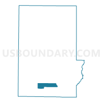
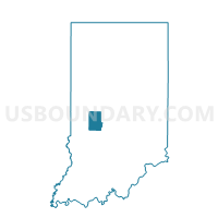
CLOVERDALE 02, Putnam County, Indiana
About
Outline

Summary
| Unique Area Identifier | 580227 |
| Name | CLOVERDALE 02 |
| County | Putnam County |
| State | Indiana |
| Area (square miles) | 6.54 |
| Land Area (square miles) | 6.46 |
| Water Area (square miles) | 0.08 |
| % of Land Area | 98.74 |
| % of Water Area | 1.26 |
| Latitude of the Internal Point | 39.52244600 |
| Longtitude of the Internal Point | -86.86207540 |
Maps

Graphs
Select a template below for downloading or customizing gragh for CLOVERDALE 02, Putnam County, Indiana


Neighbors
Neighoring Voting District (by Name) Neighboring Voting District on the Map
- CLOVERDALE 01, Putnam County, IN
- CLOVERDALE 03, Putnam County, IN
- WARREN, Putnam County, IN
- WASHINGTON SOUTH, Putnam County, IN
Top 10 Neighboring County Subdivision (by Population) Neighboring County Subdivision on the Map
- Cloverdale township, Putnam County, IN (3,929)
- Warren township, Putnam County, IN (3,929)
- Washington township, Putnam County, IN (2,493)